Choosing Between Drone Progress Monitoring and Manual Site Photo Reporting
Understanding the Two Approaches to Site Capture
Every construction or infrastructure project needs a record of what happened on site, when it happened, and how things looked. The traditional way has been manual photo reporting: someone walks the site with a camera, takes a set of pictures, and later organizes them into a report. The newer approach uses drones for progress monitoring, where a scheduled flight captures the entire site in overlapping images that are stitched into a single orthomosaic. The difference is not just about using a flying camera instead of a handheld one. It is a shift in how site capture is planned, how complete the record is, and how much effort is needed to make sense of the data.
For project managers, site supervisors, and client representatives, choosing between these methods depends on the size of the site, the frequency of updates needed, and what kind of comparisons matter most. A site capture comparison helps clarify when each option suits better, and when a mix of both might be the smartest choice.
What Manual Photo Reporting Delivers
Manual site photo reporting has been the default for decades. A person walks through the site, usually following a checklist, and takes photographs from specific vantage points. The photos are then labelled, dated, and compiled into a document that shows progress over time. The process is straightforward and requires no special equipment beyond a decent camera or smartphone and a reliable way to store and organize images.
The strength of manual reporting is its simplicity and low upfront cost. There is no need to plan flight paths, worry about battery life, or learn to process aerial data. For small sites or projects where only a few key areas need tracking, it can be perfectly adequate. The person taking the photos can also observe details that might be missed from above, such as cracks in a foundation, water pooling in a low area, or the condition of materials stored on site. Human eyes catch nuance that a camera on a drone might not isolate.
However, manual reporting has clear limitations. Coverage is inconsistent because the photographer cannot stand in exactly the same spot every time. Shadows, lens angle, and the time of day change between visits. The result is a set of images that are hard to align and compare precisely. When you lay last week's photo beside this week's, the differences in perspective can make it difficult to tell how much progress has actually occurred. The process also takes time: walking a large site, taking dozens or hundreds of photos, and then organizing them into a report can consume several hours each visit.
What Drone Progress Monitoring Brings
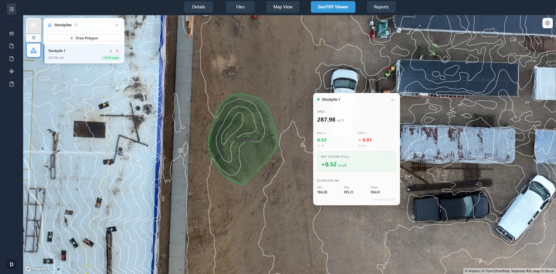
Drone progress monitoring automates much of the capture work. A drone flies a pre-programmed route over the site, taking overlapping images that can be processed into an orthomosaic or a 3D model. The flight happens at the same altitude and angle every time, so the resulting data is consistent visit after visit. That consistency is the core advantage. When you compare two orthomosaics from different flight dates, you are looking at images that align spatially. You can measure distances, calculate volumes of stockpiles, and see exactly where work has advanced.
This kind of site capture comparison is much more reliable than comparing handheld photos. Change detection tools can highlight differences between flights automatically, showing where new structures have appeared, where earth has been moved, or where materials have been placed. The output is not just a set of pictures; it is a data layer that can be annotated, measured, and shared through a client portal. For projects that need regular updates, such as weekly or biweekly flights, the drone approach builds a timeline that is easy to review and audit.
The trade-off is that drone progress monitoring requires more planning and investment upfront. You need to set up the flight plan, ensure the site is clear for the flight, and process the images afterward. Weather and airspace restrictions can delay flights. For very small sites or projects that only need a single set of as-built photos, the overhead may not be worth it.
When Manual Reporting Works Best
Manual photo reporting is still a good fit in several situations. On small residential projects, a few well-chosen photos from the ground are enough to show progress to a homeowner or a small client. The budget may not stretch to drone services, and the site area may be so compact that a drone flight would add little value. Likewise, for interior work or areas under cover, a drone cannot fly, so manual photos remain the only option. If the project has a very short timeline and the team is already on site every day, grabbing photos while they work can be more efficient than scheduling a flight.
Another case where manual reporting holds its own is when the project needs close-up detail of specific elements, such as weld quality, fastener condition, or paint finish. A drone camera, even with a good zoom, cannot match the resolution and angle of a handheld camera placed inches from the subject. For those inspections, ground-level photography remains essential.
When Drone Monitoring Adds Real Value
Drone progress monitoring becomes valuable when the site is large, when the topography makes ground access slow, or when the project requires regular, repeatable data. Large commercial developments, road and bridge projects, solar farms, and mining operations all benefit from a bird's-eye view that is consistent flight after flight. The orthomosaic produced from each flight serves as a permanent record that can be overlaid with design drawings to check that work stays on schedule and within boundaries.
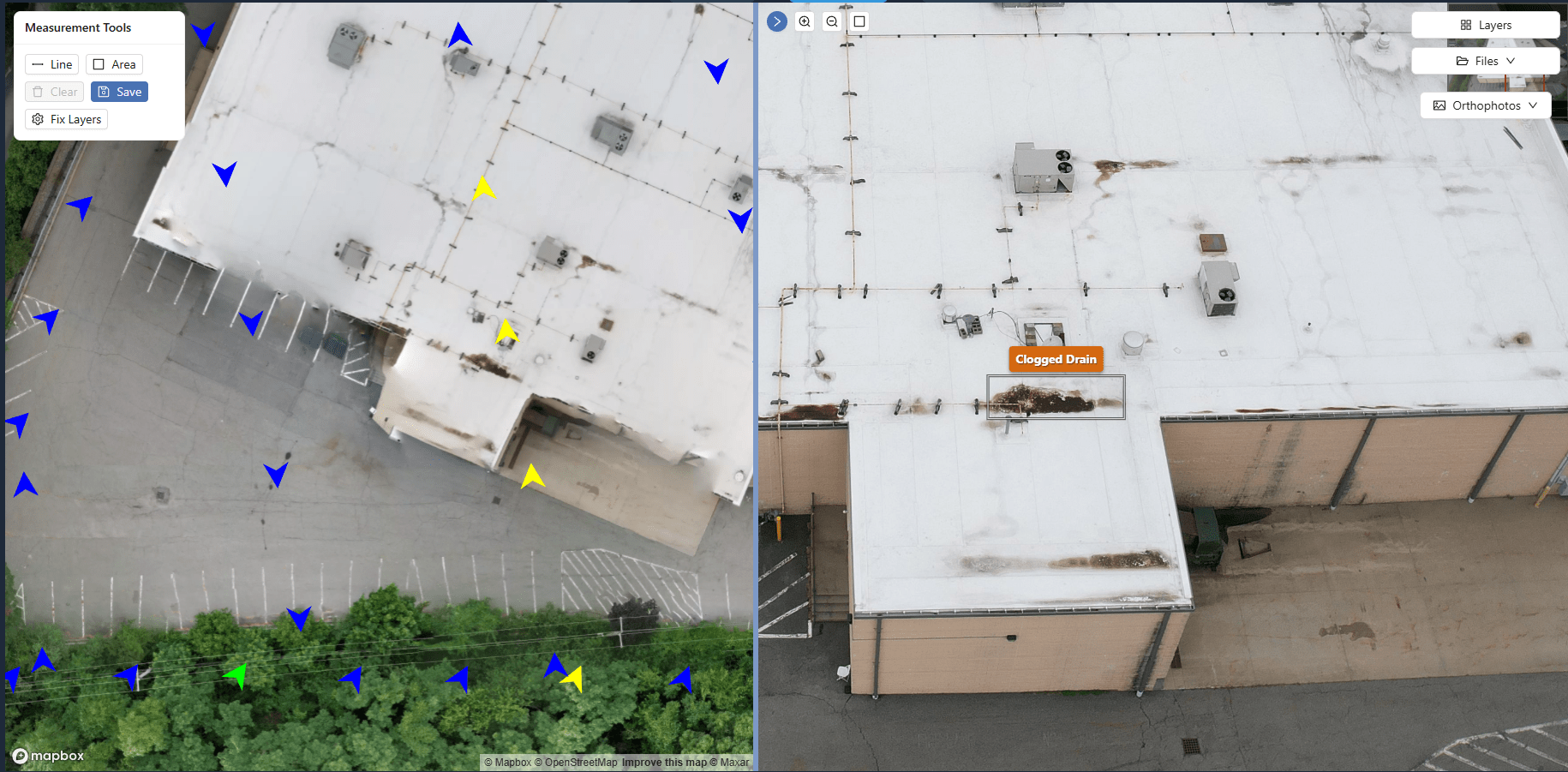
For project stakeholders who cannot visit the site in person, a drone-based report delivered through a client portal gives them a much richer understanding than a set of ground photos. They can pan around the site, zoom into areas of interest, and see the context that a ground photo would miss. The ability to take measurements from the orthomosaic also means that questions about distances or areas can be answered without a site visit.
Companies like National Drone Services provide the platform for processing, organizing, viewing, comparing, and delivering aerial imagery and mapping outputs through client portals. That infrastructure makes the drone approach practical for teams that need to share data with clients, regulators, or internal stakeholders without sending large files by email or relying on physical media.
Comparing the Costs and Effort
The direct cost of manual photo reporting is low: a camera and someone's time. But time is itself a cost, and on a large site the hours spent walking and organizing can add up. Drone flights are faster for covering large areas, but the equipment and processing software represent an investment. For one-off projects, hiring a drone service for a single flight may cost more than sending a person with a camera. For ongoing monitoring, the efficiency of drone capture often makes it cheaper per update over the life of the project.
There is also the question of data management. Manual photos tend to accumulate as files in folders, with naming conventions that drift over time. Drone data, when handled through a proper platform, stays organized by flight date and location. Annotations and notes can be attached to specific points on the orthomosaic, creating a searchable archive that does not rely on anyone's memory of where a particular photo was taken.
Making the Choice for Your Project
There is no single right answer. The best approach depends on the project's scale, the frequency of updates, the need for precision, and the budget. A sensible strategy is to use drone progress monitoring for the big picture and supplement it with manual photos for close-up details. Many projects do exactly that: a monthly drone flight provides the overall site capture comparison, while weekly ground photos cover specific work areas and interior spaces.
When evaluating options, think about who will use the data and how. If the audience is a client who wants a quick visual check, a handful of well-taken ground photos may be enough. If the audience includes engineers or regulators who need to verify measurements or track compliance, the consistent, measurable output from a drone flight is hard to beat.
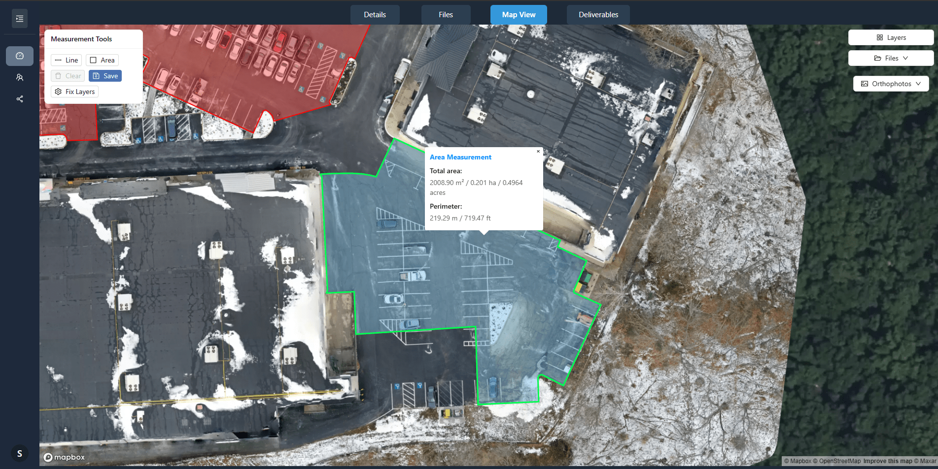
For teams that are new to drone monitoring, starting with a single flight to establish a baseline is a low-risk way to test the workflow. The orthomosaic from that first flight becomes a reference that all later reports can be compared against. After that, the decision to continue with regular flights or return to manual reporting can be based on actual experience with the data quality and the effort required.
National Drone Services supports both methods by providing a central platform where aerial imagery and ground photos can be stored, compared, and shared. That flexibility means teams do not have to choose one approach forever. They can adapt as the project evolves, using drone data when it adds value and manual photos when they are the better tool.
Ultimately, the goal of site capture is to give everyone involved a clear, honest picture of progress. The method is a means to that end. Understanding the strengths and limits of each option makes it easier to pick the right tool for the job.